At Siradel, we turn raw geospatial data into high-precision, consistent, and ready-to-use digital assets.
By combining advanced spatial processing, 3D modeling, and artificial intelligence, we build robust data infrastructures designed to integrate seamlessly into your IT systems, simulation tools, or decision-support platforms.
We empower governments, businesses, and digital players to enhance the reliability of their spatial analyses and efficiently manage their territory-related projects.

A Solid Geospatial Foundation
- 2D or 3D geodata tailored to your use cases
- Integration of diverse data sources: LiDAR, thematic base maps, field surveys, open data, IoT, and more
- Structured according to international geospatial standards (OGC, INSPIRE)
- Guaranteed spatial accuracy and consistency

Enhanced, Actionable Geodata
- Multi-source data fusion to enrich your insights
- Domain-specific attribute enrichment
- Ready-to-use, high-quality geodata
- Fully compatible with GIS and decision-making tools

AI-Accelerated Data Production
- Automated object classification and extraction
- AI-powered object recognition (deep learning)
- Faster data processing with reduced lead times
- Leverage extensive AI training datasets
A Trusted Geospatial Foundation—The Backbone of Your Project
Every impactful territorial project starts with reliable, high-quality location data.
Siradel builds strong, interoperable geospatial foundations tailored to your operational needs—from urban modeling and simulations to infrastructure management and strategic planning.
Our experts consolidate and structure multi-source datasets (3D, LiDAR, open data, IoT…) into long-lasting, high-precision digital assets that power accurate, realistic spatial applications.
Geospatial foundation | High-precision mapping | 3D urban model
Expert-Processed Data, Ready for Real-World Use
Reliable data isn’t just collected—it’s expertly refined.
We apply advanced data cleaning, normalization, fusion, and enrichment techniques to deliver cohesive datasets ready for spatial analysis, 3D visualization, GIS integration, and strategic decision-making.
Data quality | Geodata fusion | Geospatial data processing
Geospatial Intelligence—Powered by AI
To accelerate production without compromising quality, we embed AI at the core of our geospatial workflows.
Our deep learning algorithms analyze visual, topographic, and mapping data to automatically generate 3D models, detect and extract objects (trees, street furniture, etc.), and produce rich thematic maps.
This AI-driven approach enables us to efficiently process large data volumes while maintaining control over timelines and costs.
Geospatial AI | Deep learning for mapping | Automated cartography

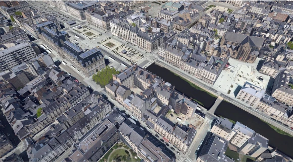
Building a 3D Digital Twin from Geospatial Data
We create high-resolution 3D digital twins by fusing precise geospatial data—LiDAR scans, aerial or high-res satellite imagery—with advanced AI-driven processing.
The result: interactive, scalable, and strategic digital environments for infrastructure planning, urban development, and simulation-based decision-making.
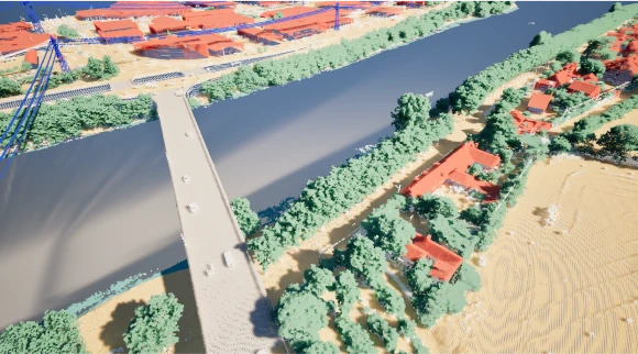
Territory-Wide LiDAR Classification and 3D Modeling
Using cutting-edge classification algorithms, we automatically identify landscape elements (buildings, roads, vegetation, etc.) from dense LiDAR point clouds.
Our AI-driven models deliver high-accuracy segmentation—even in complex environments.
These classified datasets form the basis for 3D modeling, enabling scalable analyses, simulations, and realistic visualizations fully compatible with your GIS or BIM tools.
Get answers to the most common questions about geodata and their numerous applications.
Any question ?
What is Geodata ?
Geospatial data refers to any information linked to a specific location on the Earth’s surface. It can include geographic coordinates (latitude, longitude), place descriptions, mapping layers, and data about the physical or human environment in a given area.
With modern technologies, geospatial data can now be collected in real time and seamlessly integrated into Geographic Information Systems (GIS), enabling accurate visualization and analysis of spatial phenomena.
Why is geospatial data important?
Geospatial data plays a vital role in spatial analysis, natural resource management, mapping, and geospatial intelligence (GeoInt).
By gathering and analyzing high-precision location-based information, organizations across sectors can make better, data-driven decisions in areas such as urban planning, precision agriculture, energy, insurance, and climate adaptation.
How is geodata used in the private sector ?
Private companies use geospatial data to optimize operations, manage risks, and gain competitive insights. Examples include:
- Energy & Telecom: Network planning, infrastructure deployment, asset monitoring
- Insurance: Risk assessment, claims prediction, premium adjustments based on location
- Precision Agriculture: Crop optimization through soil, water, and climate analysis
These use cases demonstrate how geospatial data supports strategic decision-making based on reliable location intelligence.
How is geodata used in the public sector ?
In the public sector, geospatial data—when combined with GeoAI (Geospatial Artificial Intelligence) and advanced visualization platforms—enables smarter, more sustainable decision-making.
Typical applications include:
- Modeling the impact of urban development on ecosystems and populations
- Infrastructure planning and asset management (roads, utilities, water networks)
- Natural hazard prevention (floods, wildfires, earthquakes)
- Climate change monitoring and adaptation strategies
How is geospatial data collected?
Geospatial data is gathered using a range of complementary technologies:
- Satellites provide large-scale information on terrain, land cover, and vegetation
- Drones capture high-resolution local data—ideal for topographic surveys or hard-to-reach areas
- Ground-based sensors measure variables such as temperature, humidity, or soil moisture
- Manual surveys and traditional cartography complete the data picture
By combining these sources, we obtain accurate, scalable datasets ready for diverse spatial analyses.
How is geospatial data processed?
Once collected, geospatial data undergoes several key steps to ensure its quality and usability:
- Data cleaning to correct errors and inconsistencies
- Harmonization to integrate data from multiple sources
- Analysis using GIS software to extract meaningful insights
- Visualization as interactive maps, dashboards, or spatial reports
This end-to-end process supports a wide range of applications—from urban planning and climate resilience to risk management and infrastructure design.