Whether you’re building a brand-new wireless network, densifying your current 5G coverage, or revisiting outdated datasets for optimized planning, one key question keeps telecom operators and radio planners up at night:
👉 Should you use 2D or 3D geodata for your telecom project?
It’s not just a technical decision. It directly affects your network performance, project cost, planning accuracy, and ultimately, customer experiencexperience and quality of service.
In this article, we break down the differences between 2D and 3D geodata for telecom, the pros and cons of each, and how to decide what’s best based on your use case, frequency bands, urban density, and deployment goals.
Understanding the Basics: What Is Geodata in Telecom?
Let’s start from the top.
Geodata refers to all geospatial datasets used to simulate and plan wireless networks. That includes information about:
- Terrain (elevation, slopes, contours)
- Buildings (footprints, heights, shapes)
- Vegetation
- Open areas (open lands, water, roads, railways, etc.)
- Urban objects ( bridges)
- Environmental parameters (clutter classes, high vegetation density)
These layers are essential for predicting how radio waves propagate in real environments — whether you’re planning a rural macro site or a dense urban hotspot.
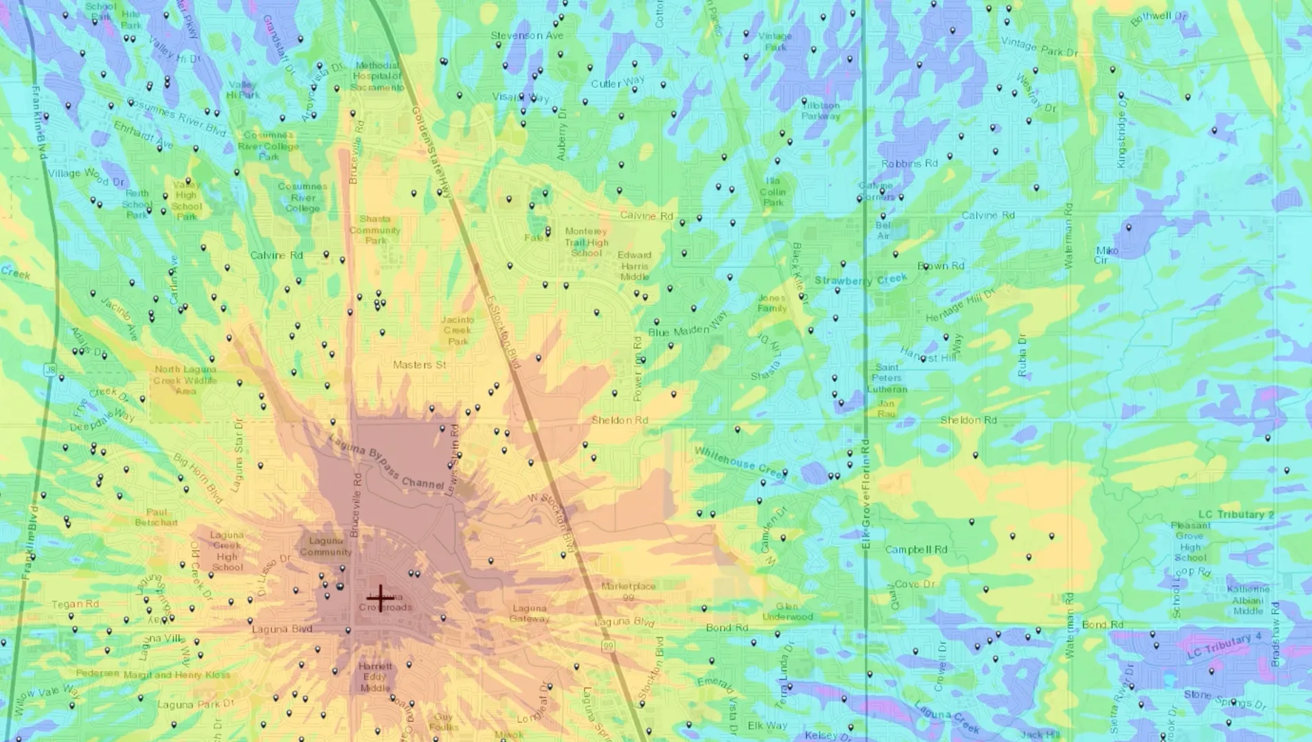
What is 2D Geodata?
2D geodata gives a simplified, horizontal view of your planning area. Think of it as a smart map with elevation baked in. Typically, it includes:
- Digital Terrain Model (DTM): Bare earth elevation values
- Digital Land Use (DLU) classes: Clutter categories (urban, forest, water, etc.)
- Raster format: Easily ingestible by radio planning tools
- And sometimes : Ortho-imagery, population data, transport network
When is 2D enough?
2D geodata works well when:
- You’re operating at low to mid frequencies (700 MHz to 2.6 GHz)
- Your project covers large rural areas with sparse country villages and small towns
- You’re focused on macro-cell network design
- You need a fast turnaround, or your budget is tight
- You’re still in feasibility phase, needing broad estimation, not micro-precision
🔎 Example: A mobile operator planning 4G expansion across farmland and villages will get accurate-enough predictions with 2D terrain and basic clutter.
What is 3D Geodata?
3D geodata, as the name suggests, adds vertical realism and volume. It’s no longer a map — it’s a 3D twin of your territory.
Advanced 3D geodata includes:
- High-resolution terrain (down to 1m)
- Detailed 3D representations of buildings (from LOD1 to LOD3)
- Vegetation canopee, Bridges, etc.
- Accurate representation of urban canyons and transport lanes (roads, high way, railways, etc.)
- Type of material characteristics (as metadata) for accurate RF simulations
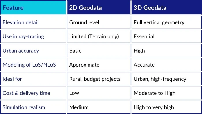
2D vs 3D Geodata: Key Differences at a Glance
Want to discover Siradel Geodata Solutions ?

Why the Type of Geodata Matters for Telecom Networks
1. Frequency Makes or Breaks Your Planning Accuracy
The higher the frequency, the more sensitive your signal is to the physical environment.
- At 700 MHz, waves go through trees, walls, and even some buildings.
- At 26 GHz (mmWave), they behave more like laser beams: blocked by buildings, and even large vegetation blocks.
Conclusion:
If you’re working with 3.5 GHz and up, especially mmWave bands, 3D is not optional — it’s mandatory for realistic simulations.
2. Line-of-Sight (LoS) & Urban Blockage Modeling
2D maps can’t tell you if a rooftop site sees its neighbors. 3D data, however, enables:
- LoS calculations between any two points (tower to tower, tower to user)
- Shadow zone analysis (where buildings block signals)
- Antenna elevation tuning (for max performance)
- Multi-layer propagation (e.g., rooftop-to-street)
This is particularly important in:
- City centers
- Dense residential zones
- Stadiums, airports, campuses
- Private networks in industrial parks
🔎 Use case: A private 5G deployment inside a logistics hub must simulate truck blockage, container stacks, metal walls. Only 3D geodata handles that level of granularity.
3. Indoor and In-Building Planning
2D geodata has no idea what’s inside a building. But 3D geodata, especially at higher levels of detail (LOD3), can provide:
- The number of floors
- The distribution of rooms indoors
- The type of partitions : concrete walls, plasterboards, windows, etc.
- The building materials including their dielectric properties This is a must for:
- Indoor coverage optimization
- Campus-wide private networks
- In-building DAS planning
- WiFi-6 or private LTE for enterprise
4. Cost and ROI Considerations
Let’s be honest: 3D data can be expensive, however there are affordable solutions! What is always expensive is redoing a deployment due to flawed simulations.
When to invest in 3D:
- You’re planning long-term, high-performance infrastructure
- You’re deploying in premium zones (CBD, venues, airports)
- Your business case depends on ultra-low latency or perfect coverage
When to stick with 2D:
- You need a rough planning base for RFQ preparation
- You’re modeling large rural areas
- Your frequency band is below 2 GHz
⚠ Pro tip: Many operators start with 2D for national footprint modeling, then selectively purchase 3D tiles for urban areas.
Real-World Deployment Examples
Case #1: Rural 5G Coverage in Eastern Europe
- Frequency: 700 MHz
- Terrain: Agricultural, forest, small towns
- Geodata: 2D with building heights
- Outcome: Cost-effective coverage planning at scale
Case #2: mmWave in Tokyo CBD
- Frequency: 28 GHz
- Terrain: Dense high-rises, reflective glass, narrow streets
- Geodata: 3D with LOD2 buildings and foliage
- Outcome: Accurate ray-tracing, optimal small cell density
Case #3: FWA Rollout in Suburbs
- Frequency: 3.7 GHz
- Terrain: Mix of 3–5 floor buildings, trees
- Geodata: 2D replaced with 3D to reduce prediction errors
- Outcome: Increased coverage prediction accuracy by 22%
Technical & Compatibility Considerations
When selecting geodata — 2D or 3D — make sure it ticks the following boxes:
Radio Planning Tool Compatibility
Your data should plug into:
- Volcano and other Siradel software
- Atoll
- Planet
- Mentum
- iBwave (for indoor projects)
- Custom simulation engines
Standard Formats
Look for:
- Vector (Shapefile, GeoJSON, KML, DXF)
- Raster (GeoTIFF, IMG, proprietary raster)
- RF-optimized formats (.xml/.bin)
Metadata & Documentation
Essential for QA and automation:
- Coordinate system and projection
- Timestamp and data age
- Accuracy level (vertical and horizontal)
- Clutter class legend
How to Decide Between 2D and 3D Geodata
Ask yourself:
- What’s my project environment? (Rural, urban, mixed)
- What frequency bands am I using? (Sub-1GHz or mmWave?)
- What is my acceptable error margin in coverage prediction?
- Do I need to plan for LoS/NLoS or indoor scenarios?
- What’s my geodata budget — and what’s the cost of inaccuracy?
If the answer to any of the above leans toward complexity, density, or precision — you likely need 3D geodata.
Pro Tip: Combine Both for Strategic Impact
You don’t always have to choose. Hybrid geodata strategies are increasingly popular:
- Use 2D for national macro planning and coverage prediction
- Add 3D tiles in high-traffic areas (CBDs, stadiums, airports)
- Maintain both in your GIS/database for dynamic modeling
At Siradel, we offer modular geodata strategies — 2D and 3D, updated regularly, aligned with your network lifecycle.
Future-Proofing: 3D Data for Digital Twins & Beyond
The value of 3D data goes beyond RF planning:
- Infrastructure asset management
- Traffic modeling
- Coordination of field engineering intervention (e.g. installation of customer premise equipment oriented toward the best antenna)
- Geo-Marketing and Geo-Targeting
- Customer support and success
- Communication
Investing in 3D geodata today prepares your organization for tomorrow’s interconnected services and cross-domain synergies.
Conclusion: Strategic Geodata Selection Drives Network Success
Choosing between 2D and 3D geodata isn’t about format — it’s about aligning data realism with your network’s technical and business goals.
| Scenario | Recommended Geodata |
|---|---|
| Rural 4G planning | 2D |
| Urban 5G Planning | 3D |
| mmWave small cells | 3D |
| FWA deployment | Hybrid |
| Private 5G for industries | 3D |
| RFQ feasibility | 2D |
| Smart campus | 3D |
Still unsure? Let our geodata experts run a use-case diagnostic and define the optimal dataset for your project.
Need updated, telecom-grade geodata for your planning project?
Contact us for a tailored dataset —2D, 3D, or both — aligned with your planning tool, geography, and goals.