In telecom organizations, RF planning data is more critical than ever — and yet still difficult to share. While engineering teams rely on advanced RF simulation tools, the rest of the enterprise increasingly needs access to the same insights to support sales, marketing, customer support, and strategic decisions.
During the Esri × Siradel webinar, Sergio Palladini, Industry Manager for Telecommunications at Esri Canada, highlighted a reality many operators recognize: telecom companies use more systems than ever, but those systems rarely communicate effectively. When RF data remains confined to engineering platforms, it no longer supports the pace and scale of modern telecom operations.
This article explains why RF data silos persist — and how ArcGIS, Siradel Webservices, and Siradel Telecom Geodata facilitate RF planning activity and enable a shift from isolated RF planning to enterprise-wide telecom insights.
RF planning underpins nearly every aspect of telecom operations: network design, coverage optimization, customer eligibility, marketing segmentation, sales qualification, and investment planning. Despite this, access to RF intelligence remains limited to a small group of specialists.
This creates a paradox: the data that matters most to the business is the hardest to share.
RF engineers work with highly specialized planning tools designed for accuracy and complexity — not for enterprise consumption. As a result, non-technical teams depend on engineers to extract maps, KPIs, and coverage views on demand.
- Sales teams wait for eligibility updates.
- Marketing waits for coverage layers.
- Customer support waits for signal quality insights.
- Leadership waits for consolidated network views.
Each request consumes time, and the outputs are often static and quickly outdated.
When RF data is distributed through exports, PDFs, spreadsheets, or screenshots, each department ends up with a different version of network reality. Marketing, sales, operations, and management base decisions on inconsistent information.
As discussed in the webinar, this fragmentation leads to misalignment, duplicated work, and reduced confidence in data-driven decisions.
Many telecom operators still rely on manual workflows: exporting RF results, importing them into GIS, converting them into reports, and pushing them into business systems. Each step introduces delays and errors while increasing the burden on engineering teams.
In a market where responsiveness matters, this approach no longer scales.
The Esri × Siradel collaboration illustrates a fundamental change: ArcGIS as the enterprise platform for RF intelligence.
ArcGIS already plays a central role in telecom organizations by acting as:
- a system of record for network assets,
- a system of insight for spatial and network analysis,
- and a system of engagement through dashboards, applications, and reports.
Because telecom networks are inherently geographic, integrating RF planning directly into ArcGIS creates a natural bridge between engineering and business teams.
Until recently, however, RF simulations could not be executed and shared directly within a GIS environment.
Siradel removes this barrier by connecting RF planning directly to ArcGIS through modern APIs.
In the workflow demonstrated during the webinar:
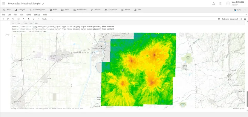
- users select network sites directly in ArcGIS Online,
- RF simulations are triggered via Siradel Webservices,
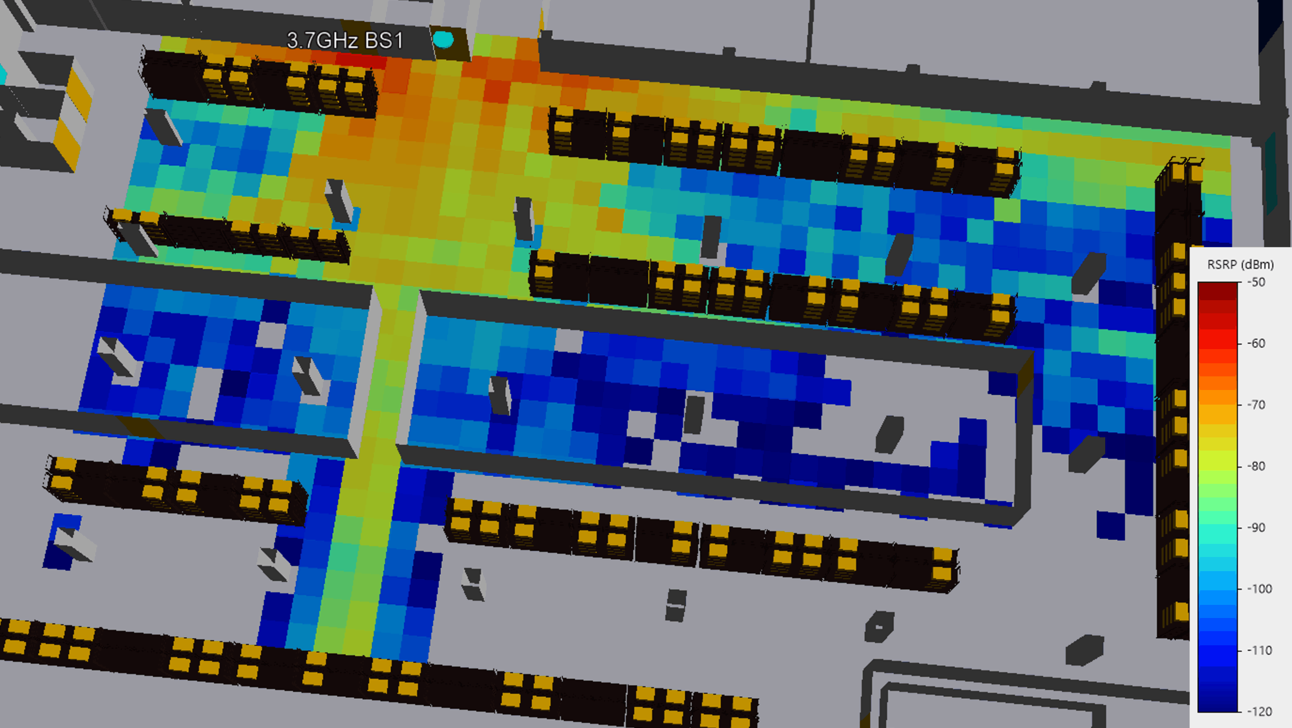
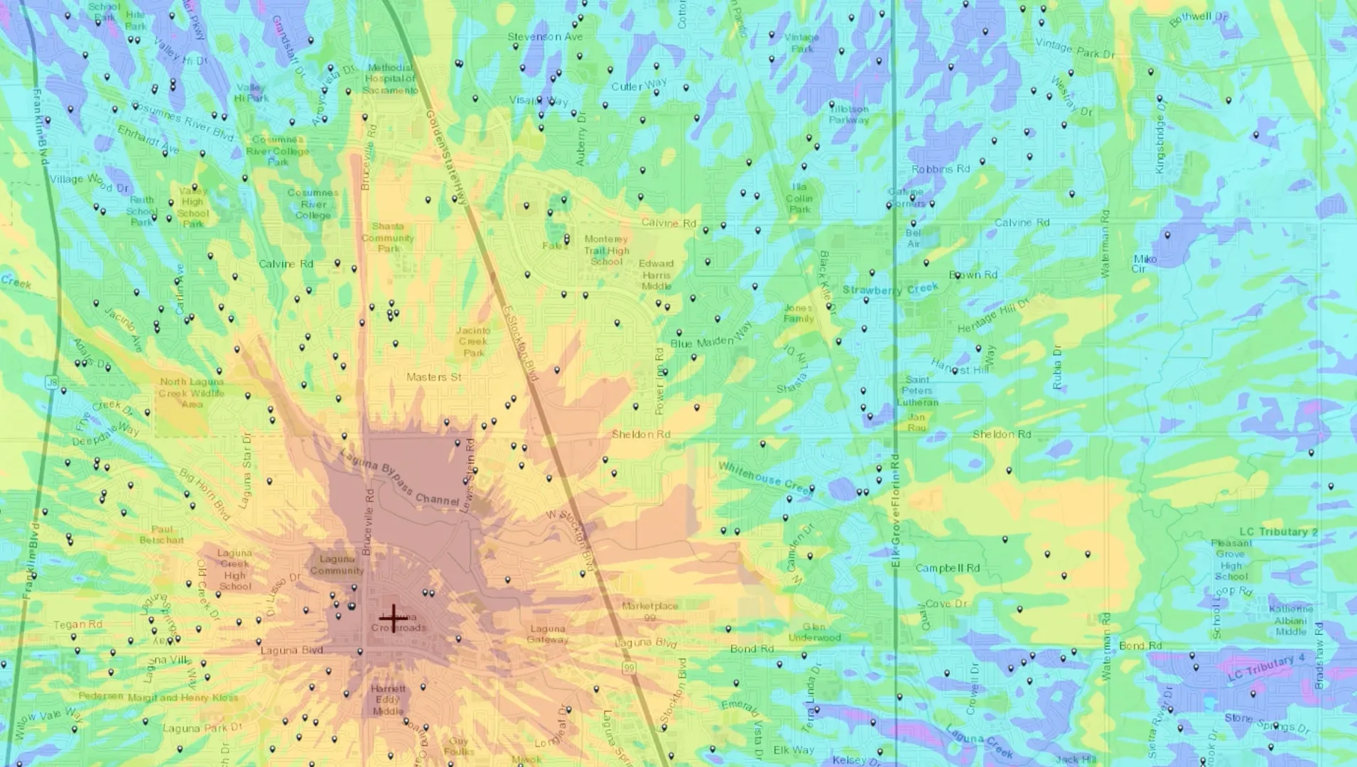
- Siradel Web Services computes coverage, best server, and KPIs using its advanced propagation models,
- results are returned automatically to ArcGIS maps and layers.
There is no export, no conversion, and no manual redistribution. RF data becomes immediately usable across the enterprise.
With this combined approach:
- Enterprise teams access consistent, up-to-date RF insights through dashboards, apps, and reports.
- Engineering teams retain control over models and parameters without becoming a bottleneck.
- Telecom-grade accuracy is preserved, thanks to Siradel geodata, high-resolution 2D/3D environments, and the Volcano propagation engine.
- ArcGIS becomes the shared collaboration space, connecting planning, marketing, sales, operations, and leadership.
By integrating ArcGIS with Siradel Webservices and Siradel Telecom Geodata, telecom operators can:
- facilitate RF planning activities,
- accelerate sales qualification,
- improve marketing targeting,
- enhance customer support,
- increase operational efficiency,
- and support leadership with real-time network intelligence.
Most importantly, every team works from the same RF truth.
This is the transition from traditional RF planning to enterprise-wide telecom insights — where RF data no longer sits in silos, but actively drives business performance.