Urban heat islands (UHIs) have become a major challenge for cities and local authorities in their quest for climate resilience. With the intensification of global warming and growing urbanization, the areas impacted by UHIs where temperatures can exceed those of the surrounding areas by several degrees represent an increased risk to the health and quality of life of residents, as well as biodiversity, and can also hinder action to reduce energy consumption.
Despite the challenges caused by UHIs, solutions exist to mitigate their effects and make our cities more liveable. These solutions range from the implementation of urban revegetation policies to the one of innovative infrastructures, driven by cutting-edge tools such as digital twins. These combined approaches pave the way for cooler, greener and more resilient urban environments.
Understanding Urban Heat Islands (UHI)
Urban heat island : Definition
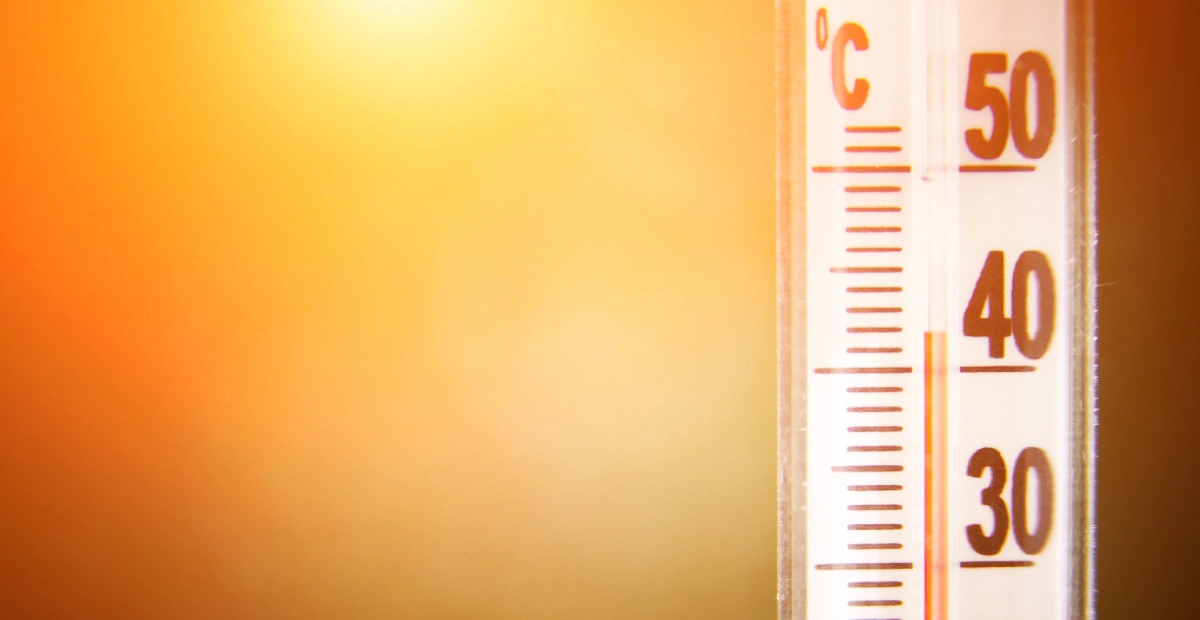
Urban heat islands (UHIs) are urban areas experiencing much warmer temperatures than the surrounding rural areas, particularly at night. This phenomenon results from the storage of the city’s heat, generated by solar radiation during the day and by human activity and infrastructure.
In other words, the heat of the sun is absorbed during the day, only to be released very slowly at night, which limits the cooling of the air, thus contrasting with the cooling in the outlying rural areas. Temperature differences at night can be as much as 12°C.
What causes urban heat island effect?
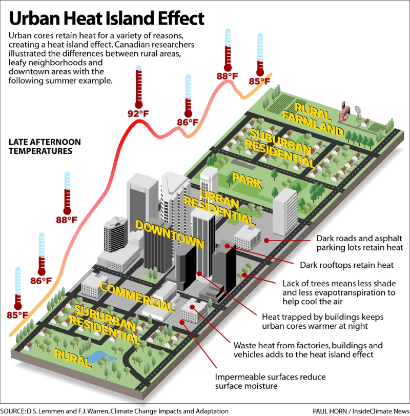
Urban heat island effect is the result of an accumulation of factors, the main ones being:
- Reduced green spaces and natural soils: urbanization contributes to shrinking vegetation in cities (trees, lawns, etc.), resulting in insufficient shading and evapotranspiration, a process that naturally cools the air.
- Density of buildings and infrastructure: concrete or asphalt buildings and roads store more heat than vegetated areas, thus exacerbating urban warming.
- Urban layout: narrow streets and tall buildings create urban canyons where warm air is less able to circulate, amplifying the effect of UHIs.
- Heat released by human activities: road traffic, air conditioning systems and industrial activities generate heat, which is then trapped by greenhouse gases (such as carbon dioxide) that act as a barrier.
The combined effect of all these factors, together with global warming and increasingly high temperatures, leads to the development of this urban microclimate.
What strategies can be used to mitigate urban heat islands effect?
In response to this growing environmental challenge, a wide range of solutions are emerging to reduce the effects of urban heat islands and improve climate resilience of cities. These strategies can even contribute to the creation of freshness islands, which are natural cooler zones in hot periods.
Bringing nature back into the city with more green spaces
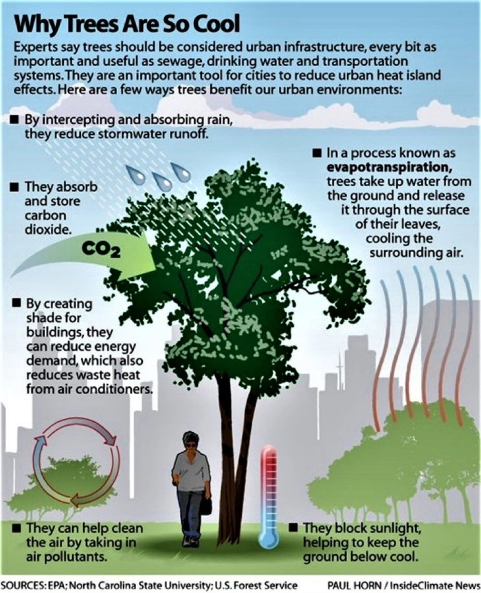
Plants and vegetation are one of the most effective solutions, contributing to the creation of urban cool islands. Urban greening offers numerous advantages:
- Trees: Trees provide shade and reduce air temperature through evapotranspiration.
- Green roofs and walls: These infrastructures absorb less heat and increase the thermal insulation of buildings, which means less need for air conditioning.
- Parks and gardens: Green spaces improve quality of life and reduce local temperatures. Studies have shown that parks can reduce the temperature in their immediate surroundings by 2 to 3°C, therefore creating urban cool islands.
Plant-based solutions (also known as ‘green solutions’) are therefore a priority investment for reducing the extent of heat islands, while helping to adapt to climate change. They have other benefits that go beyond cooling cities: carbon storage, infiltration of water into the soil, improved air quality, preservation of biodiversity, etc.
However, green solutions alone are not enough, and must be backed up by other strategies.
Using water to cool urban areas
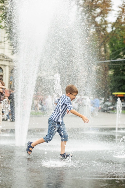
Water-based solutions (‘blue’ solutions) can also be used to cool urban spaces:
- Fountains and water features: Water absorbs and dissipates heat, helping to keep the ambient air cooler. The presence of a body of water can lower the temperature of the surrounding area by 1 to 3°C.
- Urban cooling systems: misting or evaporative cooling systems can be set up in public spaces to reduce the temperature.
These solutions not only reduce the heat, but also create pleasant and attractive spaces for residents, enhancing their quality of life in the city.
Changing citizens’ behavior and urban management
Combating heat islands also requires changes in the behavior and practices of city dwellers (‘soft’ solutions), as well as the implementation of public policies to encourage them:
- Reducing energy consumption: less energy consumption translates into less heat release. Promoting energy efficient buildings and urban infrastructure is a key element.
- Reducing road traffic and combustion engines: Encouraging soft mobility (cycling, walking, etc.), pedestrianizing streets, limiting traffic speeds, and encouraging the purchase or rental of electric vehicles are all examples of measures that can contribute to reducing the use of cars and therefore the heat generated by combustion engines.
- Awareness and education: Communicating to the public about simple measures to reduce the effects of UHIs: giving priority to public transport and bicycles, limiting the use of air conditioning, airing homes at night, closing shutters during the day, etc. These are all measures that prevent the effects of UHIs from increasing and enable populations to cope better with the heat wave.

These actions, although seemingly modest, can add up to have a significant impact and help to lower the temperature of the urban environment.
Urban design: rethinking cities, neighborhoods and urban infrastructure
Urban design or ‘redesign’ solutions (also known as ‘grey solutions’) involve improving urban infrastructure to reduce stored heat and promote air cooling:
- Increasing the albedo buildings’ surfaces: dark surfaces absorb more heat than light surfaces, which have a better albedo (ability of surfaces to reflect sunlight/heat from the sun). Building materials with higher reflectivity, such as white roofs or light-colored road surfaces, should therefore be chosen to reduce heat absorption.
- Permeable cladding: Permeable surfaces allow water to penetrate and cool the atmosphere (through evaporation), thereby reducing heat effect. They also reduce flooding risks.
- Urban design: Rethinking streets layout and buildings’ placement to create shade, maximize air circulation and minimize heat absorption.

llustration of the renovation of Pierre-Laporte car park in Victoriaville, Quebec, as part of the efforts to reduce heat islands and reintroduce nature into the city: installation of light-colored drainage paving stones, bio-retention islands, increased plant cover…
Crédits : Milieu de vie en santé
Combining all these solutions can help reduce the risk and impact of urban heat islands. Mitigation strategies are obviously specific to each territory, city or district and need to be carefully considered. A thorough diagnosis of the area and advanced strategic simulations are recommended to determine the most appropriate mitigation measures.
Urban Heat Island: how to assess a territory and identify the most appropriate solutions?
Combining different data sources and expertise is essential to effectively diagnose UHIs and identify appropriate solutions. This holistic approach allows for an understanding of the specific characteristics of the area, an anticipation of areas at risk and the development of appropriate mitigation strategies.
Combining data and expertise to better assess the territory
Get support from experts in climate change adaptation
To support local authorities in their efforts, a range of national and international organizations and programs offer expertise and support services. For instance, in France, two main national organizations support local authorities, providing tools, technical advices and financial support for urban heat islands mitigation projects : CEREMA and ADEME.
At European level, several organizations and programs are focused on combating urban heat islands. Below are some examples :
- Horizon Europe: The EU’s research and innovation program funds project that includes solutions for urban heat islands, focusing on technological innovation and integrated approaches.
- LIFE Program: This EU funding program supports environmental and climate projects, including those aimed at reducing urban heat islands through nature-based solutions and green infrastructure.
- Climate-ADAPT: Managed by the European Environment Agency (EEA) and the European Commission, this platform provides information and tools to help communities adapt to climate change impacts, including urban heat island effect.
- URBACT: A European program promoting sustainable urban development. It funds projects and networks of cities that share best practices for tackling urban heat islands.
- Joint Research Centre (JRC): The JRC provides policy support and scientific research on managing extreme heat in cities, including strategies to mitigate urban heat islands.
- United Nations Environment Programme (UNEP): Through the Cool Coalition, UNEP supports sustainable urban cooling solutions and has published resources like the “Sustainable Urban Cooling Handbook”.
Finally, some cities are taking part in research programs, in partnership with universities and research institutes, to develop innovative solutions and incorporate best practices to their local needs.
Generate and use local data
To assess an area and identify urban heat islands, several types of data can be used:
- Climate data: National and local weather stations can provide data on local temperatures down to the level of neighborhoods. This is an important resource in identifying urban heat islands.
- Geospatial data: Satellite and drone imagery as well as land-use maps help analyze urban surfaces (materials, vegetation) and visualize the factors that influence the formation of urban heat islands.
- Social and economic data: using official statistics organisms or municipal databases, it is possible to identify the most vulnerable areas to UHI on the basis of population density, average age or economic status.
- Environmental data: strategically placed sensors measure temperature, humidity and other environmental parameters, providing accurate local data.
To take full advantage of the territorial data collected, it is essential to integrate, cross-reference and analyze them in a coherent way. This is where the digital twin comes in as a powerful tool. It aggregates all this information, provides a precise diagnosis of UHIs, and facilitates decision-making by simulating different intervention scenarios.
The digital twin, a powerful diagnosis and decision-making tool
The digital twin allows the centralization of all the territory’s data. It can be used to diagnose, simulate and optimize cooling measures in the city, while facilitating collaboration between all stakeholders. Siradel has developed an innovative approach to combating urban heat island effect based on the use of the territory’s digital twin.
Digital twin to diagnose and identify UHIs
Taking into account all local parameters: population density, type of buildings, existing vegetation, etc., the digital twin allows for an accurate modelling and mapping of urban heat islands. This modelling provides a detailed heat map identifying the most affected areas and the degree of ‘severity’ of the phenomenon.
More importantly, it can be used to correlate multiple criteria, such as the hottest areas, with socio-demographic data to identify the most vulnerable populations and prioritize efforts to better protect them.
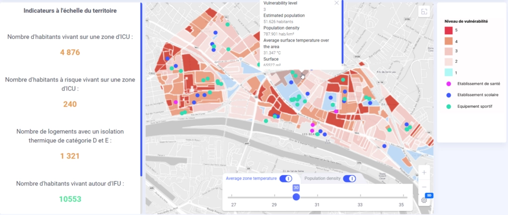
Calculation of vulnerability index – cross-referencing data relating to urban heat islands and populations at risk, Siradel
Simulate, plan and prioritize measures to mitigate urban heat islands
The digital twin, as a true virtual representation of a territory, can be used to simulate different transformation scenarios to identify the most appropriate one based on the objectives defined, to calculate customized indicators to better understand the territory and its evolution, and to engage and raise awareness among multiple stakeholders.
As a result, it is an ideal decision-making and planning tool that provides a clear vision of possible operational responses.
Deploy response solutions and assess their impact
The digital twin can also be used to measure the impact of action plans by tracking changes in urban temperatures after solutions have been implemented, thereby helping to manage climate resilience projects.
Results can be shared with the public and decision-makers via interactive platforms, improving local authority transparency and communication about the chosen mitigation strategy and its impact.

Key Facts
- UHI is defined as a urban area experiencing higher temperatures than the surrounding rural areas, particularly at night.
- Causes of urban heat islands include building density and materials, vegetation reduction and human activity, which increase heat storage and slow cooling of urban areas at night.
- Urban greening, optimized infrastructure (reflective materials, white roofs), behavioral changes (soft mobility, etc.) and better water management in the urban environment are some of the solutions to mitigate urban heat island effects.
- Digital twins are essential tools to diagnose, simulate, plan and measure the effectiveness of measures and solutions deployed to combat UHIs.
- Siradel is an expert in the creation of digital twins. We support local authorities in their efforts to tackle UHIs and adapt to climate change. If you would like more information about our solutions, please contact us at: contact@siradel.com